
This three-part post began here last week; you may want to start there if you missed it, to get a sense of what this is about. In essence it's a tribute to a wonderful park, which is currently burning, and has been since 27 January. The post is in response to the fire, to remind us all of the beauty and wonders of Namadgi as they were and will doubtless be again, but it is not about the fire. Today it's about some of the plants of Namadgi; next time it will the animals' turn.
 |
| Candlebark Gum Eucalyptus rubida, Yankee Hat Walk carpark, Old Boboyan Road. |
However before I start the beauty parade I would be remiss not to update you on the fire, which unfortunately I was wildly optimistic about last time as it turned out. Two shocking days last Friday and Saturday (40 degrees and capricious winds), and gloriously/hideously rugged country (depending on your needs) made it impossible to contain. Efforts were quite understandably concentrated to the east where the country is populated with rural properties and small townships. To the west, where the border runs along a high ridge of the Brindabella Ranges, through Snow Gum woodland and subalpine bogs and meadows, little could be done and, as I desperately hoped it wouldn't, the fire's now up there, at least in the south but creeping north. As far as I can tell it's still OK north from about Mt Gingera, but it's hard to see what will stop it, unless the promised rains are heavy enough, and soon enough. On the plus side it's probably creeping relatively slowly at present, based on the rate of spread, so the intensity probably isn't as bad as it was in 2003, when it roared up the other side from the west, burning so fiercely that much of the organic matter was burnt from the soil.
As of today (6 February) it has burnt 85,000 hectares of Namadgi, 80% of the park. You may want to look away from this map! (For updates, see here and zoom in.)
 |
| The approximate extent of the fire as of the afternoon of 6 February. (I've only indicated the extent within Namadgi, which is the green area within the ACT. It's also burning outside the ACT to the east and, increasingly, to the west.) |
But now let's do what we came here for, which is to look at a selection of the plants we've enjoyed in previous kinder seasons - and it's important to recall that we'll enjoy them again in due course. Atypically I'm not going to offer too much information; this is a time to enjoy and ponder on the past and the future. (Also I've included more than I'd intended, but so many lovely plants put irresistible cases to me for inclusion. If it's too much for one sitting you can always come back later.)
Let's start with some daisies, of which there are many species to brighten the day at any altitude. (I've opted to adopt the common names from Meredith Cosgrove's excellent Photographic Guide to Native Plants of the Australian Capital Territory; the actual photos however are, as ever, mine. In some of them signs of the 2003 fires, mostly in the form of dead Snow Gums, are evident.)
 |
| Hill Daisy Brachyscome aculeata in the high Brindabellas, above and below. |

 |
| Spoon-leaved Daisy Brachyscome spathulata, Mount Ginini. |
 |
| Snow Daisies Celmisia sp. above and below, high Brindabellas; even when not flowering the silvery hairy stems shine in the sun. |
 |
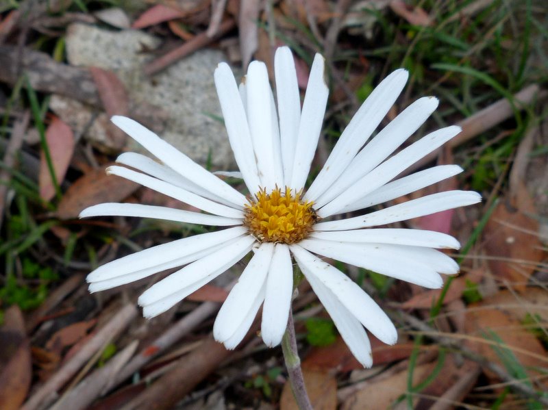
| Alpine Sunray Leucochrysum alpinum, restricted to the high mountains. |
 |
| Showy Copperwire Daisy Podolepis jaceoides, high Brindabellas. In early Decembert these can cover large open areas such as follow the ACT-NSW border break along the ridge line on the Mount Franklin Road. |
 |
| Ovens Everlasting Bush Ozothamnus stirlingii, near Bulls Head. |
 |
| Large-leaved Daisy Bush Olearia megalophylla, Booromba Rocks. Often found as an understorey to the Alpine Ash forests. |
 |
| Sticky Daisy Bush Olearia tenuifolia, Mount Tennent. A big bush with striking flowers, uncommon in Namadgi in rocky areas, found mostly here at the north-eastern edge of the park. |
 |
| Blanket Bush Bedfordia arborescens, a small tree of the wet gullies, which grows to five metres high and is Australia's biggest daisy. |
 |
| And here's why it's called Blanket Bush; the undersides of the 20cm long leaves are densely woolly. I've seen a honeyeater nest cosily lined with this wool. |
Peas are another predominant family (and even more so if we go along with the current orthodoxy that wattles belong within the family, rather than as a closely related one). Last week's post featured a couple of species providing mass flowering in the landscape, but here are three more, all from under the Snow Gums of Mount Ginini.
 |
| Gorse Bitterpea Daviesia ulicifolia. Unlike the next two, this species is also found right down to the hills around Canberra. |
 |
| Golden Shaggy-Pea Oxylobium ellipticum, which does grow down to the foothills but is commonest, indeed dominant, up in the Snow Gums. |
 |
| Alpine Shaggy-Pea Podolobium alpestre; this too can form a dense understorey to the Snow Gums. |
I have no interest today in getting involved in taxonomic quibbles, so it may or may not be coincidence that wattles here follow the peas... For more on wattles of the ACT see here; for today though, here are just a couple from different parts of Namadgi.
 |
| Mountain Hickory Acacia obliquinervia, Mount Franklin Road. This was taken less than three years after the 2003 fires, as the dead Snow Gums suggest. |
 |
| Red-stemmed Wattle A. rubida, south of Tharwa, eastern Namadgi. |
In the high mountains members of the family Proteaceae aren't as prominent as they are lower down, but there are some striking ones scattered in the understorey.
 |
| Small Royal Grevillea G. diminuta, Mount Franklin Road between Mounts Franklin and Ginini. (The odd common name, which is contrived, is based on the fact that it was originally believed to be a subspecies of Royal Grevillea, G. victoriae.) And it grows only along this stretch of the Brindabellas (plus a couple of nearby ACT sites). And I'm going into the sort of detail that I undertook not to! Sorry... |
 |
| Woolly Grevillea G. lanigera, Mount Franklin. |
 |
| Alpine Orites O. lancifolia, Mount Ginini. A big showy shrub, not common in accessible parts of the ACT. |
 |
| Velvety Geebung Persoonia subvelutina, Mount Franklin Road. Not common. |
Some more shrubs from various families, before ending with some herbs.
 |
| Drumstick Heath Epacris breviflora, Mount Ginini. One of several heaths that grow in the high bogs and seeps. |
 |
| Derwent Speedwell Veronica (but widely known as Derwentia) derwentiana. |
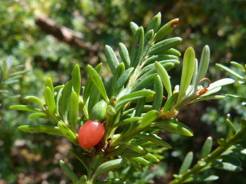 |
| Mountain Plum Pine Podocarpus lawrencei Mount Ginini; female above, male below. This is the only mainland Australian alpine conifer, growing as a sprawling shrub in the high Alps. It grows slowly, and must start from seed after a fire. There's a little more about them here including the true nature of the red 'fruit'. |

 |
| Alpine Pepper Tasmannia xerophila, Mount Ginini, female above, male below. |
 |
| The family Winteraceae is found in both Australia and South America; it is one of the most ancient of living flowering plant groups. |
And back to lower eastern parts of Namadgi, and in particular the grand rocky slopes of Mount Tennent above the Namadgi Visitors' Centre and the village of Tharwa.
 |
| Fringed Heath Myrtle Micromyrtus ciliata. This is about the only place in the ACT that it grows, though it is widespread on sandstone closer to the coast. |
 |
| Woolly-headed Pomaderris P. eriocephala, above and below. |

And one more shrub, this time from the wet gullies low in the ranges.
 |
| Victorian Christmas Bush Prostanthera lasianthos, lower Warks Road. Magnificent in mid-summer along the creeks; the common name's a bit rich, as it grows from Tasmania to (just) southern Queensland! |
And finally a few herbs, of the many that make a visit to Namadgi such a pleasure in a good season, starting with some lilies. (There's more on these and other lilies starting here.)
 |
| Vanilla Lily Arthropodium milleflorum, near Mount Franklin. These grow at all levels, and when flowering en masse the scent is glorious. |
 |
| Rock Lily Bulbine glauca. |
 |
| Blue (or Mountain) Flax Lily Dianella tasmanica, Mount Franklin Road, above and below. |
 |
| The glossy purple berries can be as lovely as the flowers. |
Some random herbs, then we'll end on an orchid fanfare!
 |
| Sheep's Burr Acaena ovina. A member of the rose family, but wind-pollinated. Its sticky burrs travel in wombat and wallaby fur, and socks. |
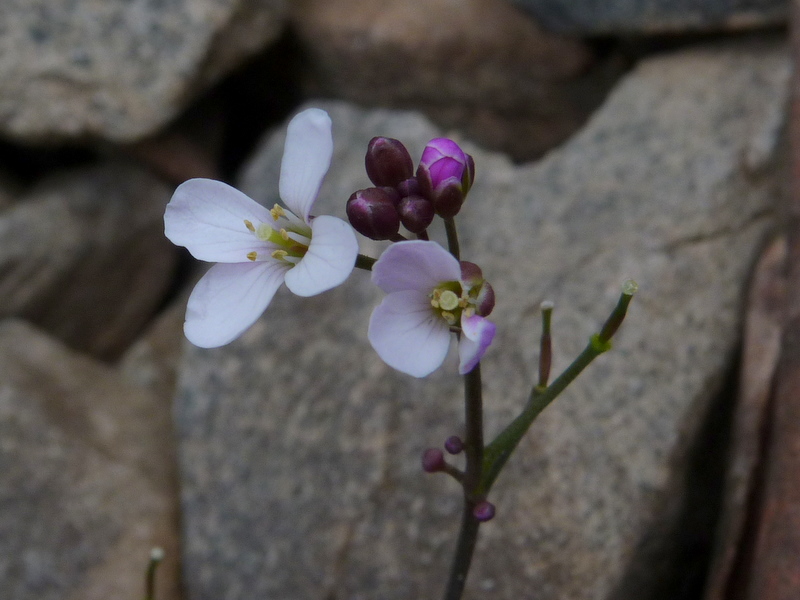 |
| Bitter-cress Cardamine sp., Mount Ginini. |
 |
| Rock Fern Cheilanthes sp., Mount Tennent. These hardy ferns thrive in harsh dry rocky situations. |
 |
| Willowherb Epilobium gunnianum. (I think! There are a couple of very similar species.) |
 |
| Purple Eyebright Euphrasia collina. A widespread and ever-cheerful little herb, which attracts many pollinators, some of which we may well meet next week. |
 |
| Native Geranium G. solanderi; common, widespread and attractive |
 |
| Ivy Goodenia G. hederacea; brightens roadside banks throughout the park. |
 |
| Matted Pratia Pratia (or Lobelia) pedunculata. An inconspicuous little ground cover of damp places. |
 |
| Candles Stackhousia monogyna, Mount Ginini. A familiar, very lovely and showy herb which grows from the Snow Gums to Canberra (and to sea level and in every Australian state). |
 |
| Prickly Starwort Stellaria pungens, which has been a favourite of mine since I drove up to the Brindabellas in December 2003, and found the ground covered with it for tens of kilometres of road and as far into the surrounding understorey as we could see. Within a couple of years it was back to being a common enough but scattered small herb, but presumably there is again a vast seed bank waiting in the soil for the next post-fire call. |
 |
| Black-eyed Susan (or Mountain Pinkbells) Tetratheca bauerifolia can provide banks of pink-purple along the Mount Franklin Road. |
 |
| Mountain Violet Viola betonicifolia, another favourite, growing as a single upright plant unlike the other common, and more familiar, native violet V. hederacea. |
 |
| Royal Bluebell Wahlenbergia gloriosa grows in damp banks in the high mountains; it is also the ACT's plant emblem, though most Canberrans never see it in the wild. |
Which brings us to some orchids; many who know me won't be at all surprised that I'm ending this post with them.
 |
| The lovely Alpine Caladenia C. alpina grows scattered under the Snow Gums. |
 |
| Hyacinth Orchid Dipodium roseum, upper Warks Road. A dramatic leafless orchid growing to 80cm tall. |
 |
| Brindabella Potato Orchid Gastrodia entomogama, Mount Franklin Road. Another leafless orchid, restricted to the Brindabellas, in Namadgi and adjacent NSW. |
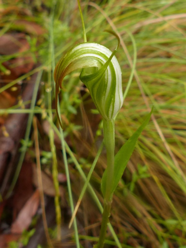 |
| Summer Greenhood Pterostylis (Diplodium) decurvum, which grows in moist grassy Snow Gum sites. |
 |
| Mountain Black-tip Greenhood Pterostylis (Hymenochilus) crassicaulis. An uncommon and inconspicuous little orchid of open grassy areas, such as along the border break alongside the Mount Franklin Road. |
 |
| Mountain Sun Orchid Thelymitra alpina, a sun orchid of drier open slopes. |
 |
| Collared Sun Orchid Thelymitra simulata grows in similar situations to the previous species. |
And that's a wide-ranging and hopefully leisurely and enjoyable tour of some of the plant delights of Namadgi National Park. There should be no sadness or regret in viewing them; none of them will disappear as a result of the current fire. Some of them would probably not have flowered this droughted summer anyway. But with luck and rain most of them will be back on show next summer, and that's something to look forward to.
Good luck with dealing with the next week if you're in my part of the world, though the promised rains should make it a much more hopeful one. Next week I'll conclude this Namadgi celebration with a fond look at some of its animals; hope you'll be back for that.
NEXT POSTING THURSDAY 6 FEBRUARY; you can find it here.
And remember that you can get a reminder when the next post appears by putting your email address in the Follow by Email box in the top right of this screen.
I'd love to receive your comments - it's easy and you don't need to sign in!
And remember that you can get a reminder when the next post appears by putting your email address in the Follow by Email box in the top right of this screen.
I'd love to receive your comments - it's easy and you don't need to sign in!


