
I write this in quarantine in chilly Canberra; like thousands of others we are isolated at home for two weeks as a result of having been in the same general area and time as someone who later tested positive. No complaints, we've all got to do our bit, but we'd much rather be travelling, so I'm going to indulge instead in putting together a two-part blog on one of our very favourite parts of Australia, the ancient and sublime Tjoritja. They were renamed the MacDonnell Ranges by the doughtiest of early European explorers here, the Scot John McDouall Stuart in 1860. (MacDonnell was the South Australian governor at the time.) There is a gradual move towards reinstating the old Arrernte name, at least as an alternative, though I don't anticipate a general take-up among 'whitefella' Australians in the near future. However it is intended that the European name be eventually phased out. The ranges are divided for convenience into the East and West MacDonnells, the pivot being the fascinating and troubled town of Alice Springs.
As mentioned, this is a two-part blog, with some of the plants and animals of the range featuring next time. Nonetheless I'm finding that this is a longer post than usual, possibly because I have more time than usual on my hands at present, but also because of the scope of the topic.
 |
| Two views of the Western section of Tjoritja, from the Larapinta Road which runs west from Alice Springs along the range. One of the most scenic sealed drives in the entire continent. |

 |
| A more distant view of western Tjoritja across the plains from Ewaninga, south of Alice Springs. |
 |
| A somewhat unusual perspective, from the north, from the Gary Junction Road. Note that a permit is required for this road through Indigenous land. |
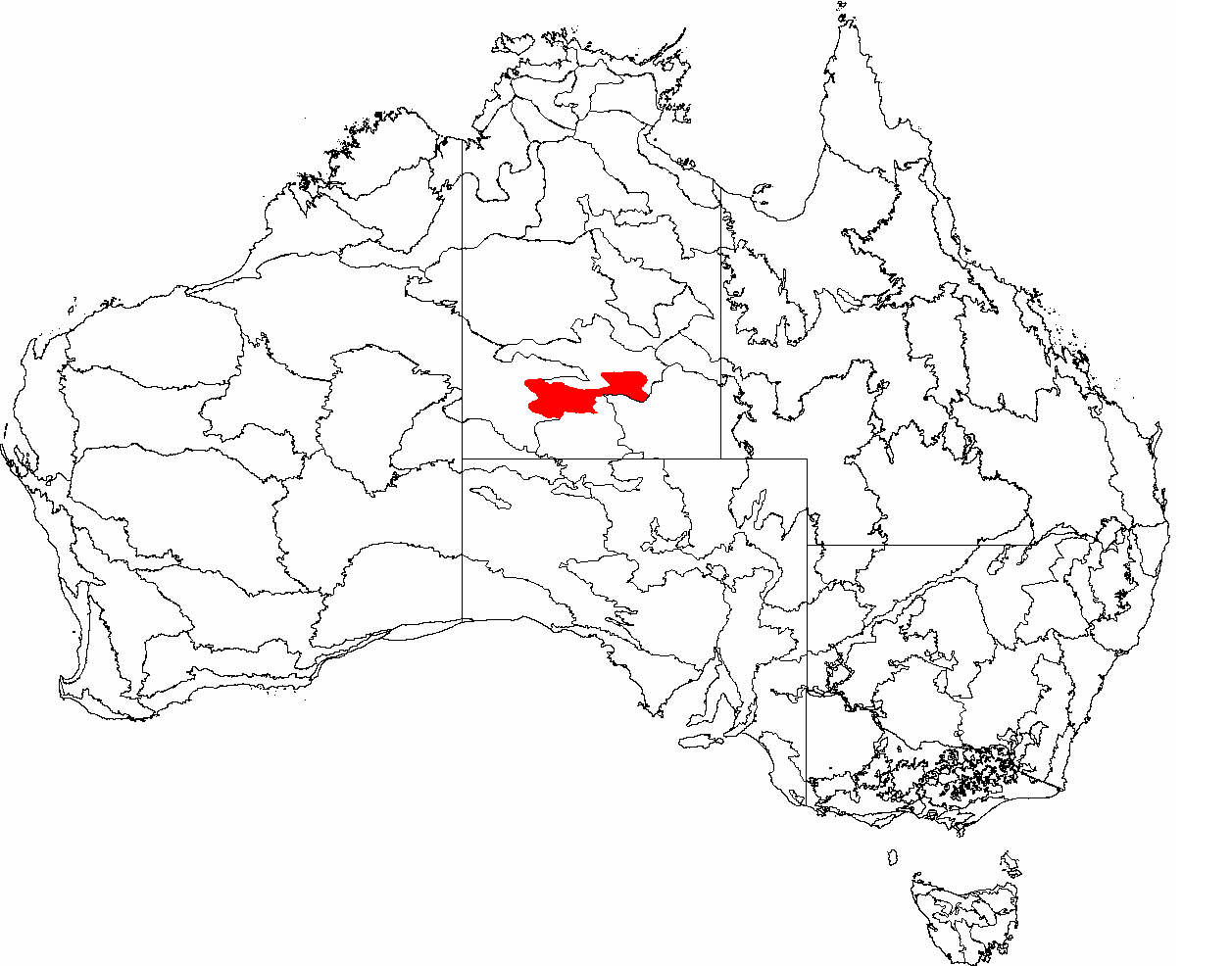 |
| Tjoritja marked in red; map courtesy Wikipedia. Alice Springs (just 'Alice' to her many friends) lies in the narrow section in the middle of the range. |
 |
| The range runs west-east, as seen in this shot from Google Earth. Only the western section is substantially protected as a reserve, and that is where most visitors go. The range extends further to the the east than I've shown here, but access is relatively limited beyond that. The numbers represent the places discussed and illustrated below. 1, Redbank Gorge/Yarretyeke; 2, Mount Sonder/Rwetyepme; 3, Glen Helen Gorge/Yapalpe; 4, Ormiston Gorge/Kwartatuma and Pound; 6, Ochre Pits; 5, Serpentine Gorge/Ulpma ; 7, Ellery Creek Big Hole/Udepata; 8 Standley Chasm/Angkerle Atwatye; 9, Simpsons Gap/Rungutjirpa; 10, Emily Gap/Yeperenye; 11, Corroboree Rock; 12, Trephina Gorge/Alherrkentye and John Hayes Rockhole/Atneperrke. |
 |
| The geology of Tjoritja is complex and very diverse, though the predominant rock in most places is iron rust-stained red quartzite, which features in many of the photos that follow. |
 |
| Red quartzite in the walls of Rungutjirpa gorge, and in nearby outcrops (below in the early morning). |

 |
| The magnificent view from Cassia Hill and (below) a closer shot of the two lovely Ghost Gums Corymbia (or Eucalyptus) aparrerinja; more on them in the next post, but if you can't wait, follow this link to a full post on them. |

 |
| Standley Chasm/Angkerle Atwatye; I find it very hard to get the light right here! Unlike all the other gorges this one is privately owned (by the local Western Arrernte community). There is a small entrance fee, but well worth it. |
 |
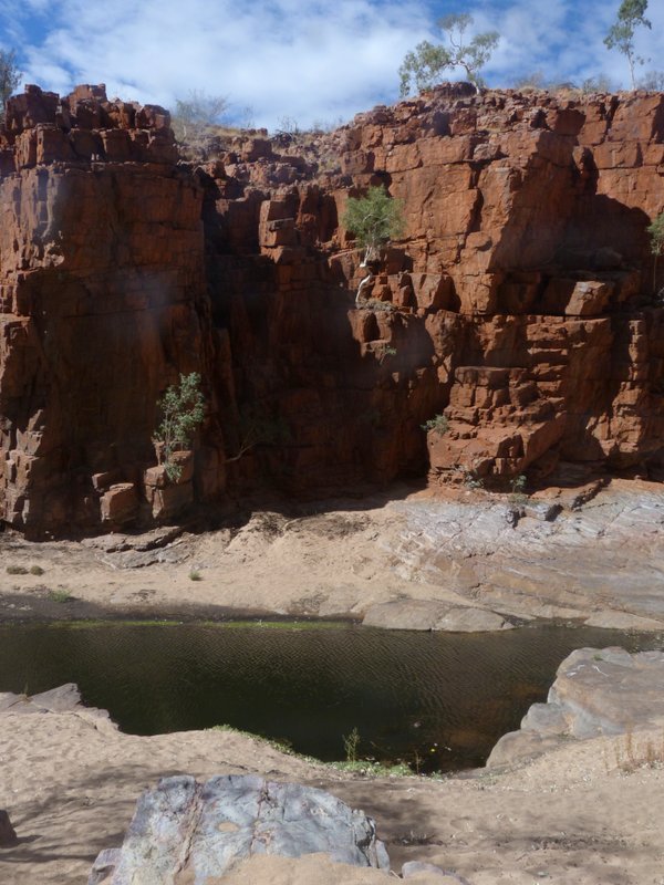
| Udepata in a more peaceful moment. When it's like this the bird life is usually busy here. |
The Ochre Pits, a little further west, are much easier to access and while no gorge is involved, the walk follows a dry creek bed featuring low colourful cliffs on one side. The ochre has been extracted by the Arrernte people for thousands of years for artistic and ceremonial purposes.
 |
| The spectacular rocks alone make this walk worthwhile. |

 |
| Away from the creek the track passes through superb mature spinifex; it was here that I saw my first Rufous-crowned Emuwrens, Australia's smallest bird, many years ago. And I've never seen them in Tjoritja since. |
 |
| An early view of Rwetyepme from Namatjira Drive. |
 |
| A closer, sharper view. |
 |
| A less familiar view of Rwetyepme! Rain and cloud on a dry landscape. |
 |
| Near the start of the walk, looking back to Ormiston Creek where it starts. The spinifex-covered hills are typical of the route. |
 |
| Looking back to Mt Sonder as we climb and it appears over the ridge behind us. |
 |
| Looking down into the pound from the lookout. |
 |
| The Pound from within. This was a particularly dry year. |
 |
| Inside the gorge we are walking along the sandy creek bed initially, sometimes climbing over spectacularly coloured tumbled stones. River Red Gum saplings generate in the bed and White Cypress Pines and Ghost Gums grow on the cliffs. |
 |
| Once we get to the long, very deep pool it's a bit of a lottery. Sometimes - perhaps mostly - you can just walk past it, but I've also seen it so full that a lot of rock scrambling was required. Last time I was there though it was so high that the walk through the gorge was closed, but I don't imagine that happens very often. |
Nearby, but south of the road, is Glen Helen Gorge/Yapalpe, where the Finke/Larapinta River flows south through the range. It's a lovely little gorge, which always seems to have a lot of bird life, with a low key (but high cost) lodge comprising motel, campground and restaurant/bar alongside. It has recently changed hands, so I can't comment further on what it's like now.
 |
| Magnificent cliffs with fascinating folds and sediment layers across the river from the lodge. |
 |
| Dramatically eroding cliffs above the gorge. |
 |
| The Finke/Larapinta River within the gorge is impressive indeed; above turbid after rains, below clear, as it is most of the time. |

A short walk back along the entrance road leads to a superb lookout across the plains and the River Red Gum-lined Finke/Larapinta River to Rwetyepme. It's especially fine in the evening.
 |
| Evening looking across the Finke/Larapinta to Mount Sonder/Rwetyepme from the entrance road to Glen Helen/Yapalpe. |
 |
| Gum-barked Coolibah woodland (in the rain), Yarretyeke campground. |
 |
| Ghost Gums on the lip of Redbank Gorge. |
 |
| Walking into the gorge. |
 |
| Permanent pool in the gorge. |
 |
| Yeperenye paintings on the lower walls of 'Emily' Gap. |

 |
| Corroboree Rock. |
 |
| Ghost Gums and spinifex on the hills near Corroboree Rock; a grand land. |
 |
| Climbing up to the plateau from Trephina Creek, at the start of the walk. What a backdrop! |
 |
| Red quartzite outcrops high above the creek. |
 |
| Looking down on the broad bend in the creek. The track descends to the creek behind the tall outcrop in shadow in the back left. |
 |
| A beautifully lit River Red Gum in the creek, and Mulga (Acacia aneura) on the harsh rocky slopes above. |
 |
| The walk back along the creek provides some welcome shade on a warm day, though the sand can drag on the feet! |
 |
| The rockhole is usually more impressive and inviting than it was then, though it was doubtless of great value to local wildlife in those dry conditions. |
 |
| The shady red rock-strewn gorge. |
 |
| Moonrise in western Tjoritja. |
for some plants and animals of the range; you can reach it here.
I love to receive your comments and in future will be notifying you personally by email when a new posting appears, if you'd like me to. All current subscribers have been added to this mailing list and have already been contacted.
This will mean one email every three weeks at the current rate of posting.
Should you wish to be added to it, just send me an email at calochilus51@internode.on.net.
You can ask to be removed from the list at any time,
or could simply mark an email as Spam, so you won't see future ones.
6 comments:
Thanks Ian. Another wonderful collection of photos and comments.
Inexplicably Tjoritja has only received cursory visits - you convince me of the need to rectify this as soon as possible.
Cheers, Warren
Hi Warren. And thanks for convincing me that my life hasn't been entirely in vain then! Yes, you must.
A wonderful account of glorious country. Have you visited N’Dhala Gorge in the eastern Range? I haven’t but am curious about it.
Thank you for those kinds words Dominic (I'm guessing at that!). No, while I was writing I realised that we've not been to N'Dhala, and I can't remember why not. I must rectify that next time we go there.
Nice to do some armchair travelling in such spectacular country. I look forward to the next post to see some of the local fauna and flora. Pity about the dingo.
Thanks Kath, glad you're enjoying it. It was therapeutic to put it together too. Yes, people don't think about the consequences of their lack of thought (ie re the dingo).
Post a Comment