
How to talk about an entire country - especially one as special as Costa Rica - in a single blog post? Well of course I can't meaningfully do so, so I'm going to break it into three posts, the second and third being on birds and other animals. This one will be something of a scene-setter, briefly introducing the origins, habitats and regions of this tiny land - well, tiny by Australian standards at least, only about 75% of the area of Tasmania, our smallest state. However it is bursting with diverse tropical life, especially in the rainforests which rise from sea level on both coasts high into the mountains.
Moreover it is fascinating too in other ways, even within the already fascinating context of Latin America. Since independence in the early 19th century there has been a strong narrative of social welfare and justice that put it ahead of much of its time, such as the introduction of eight-hour working days, tenancy protection laws and workplace safety laws in the 1920s. Famously Costa Rica abolished its military in 1949, and diverted a good part of the money saved into education and health, in both of which it is a leader. More recently it committed itself to 'decarbonising' the economy and achieving carbon neutrality, which it had virtually reached when we were first there in 2019. Unfortunately the current president has backed away from that, and weakened Costa Rica's previous excellent stance in responding to COVID, citing a need to 'reassure the private sector'. But in Costa Rica, presidents come and go and it's hard to see this country abandoning lofty social and environmental goals for long.
That's not my area of competence though, so we'll return to the more natural aspects of the country.
 |
| Rich cloud forest at 1400 metres above sea level at Monteverde, on the northern central Pacific slopes. |
Central America is a somewhat amorphous concept - it is certainly not a continent, but the southern end of North America. The UN defines it as the area (including eight countries) between the top of Mexico and the top of Colombia; another definition excludes Mexico, leaving only, from north to south, Belize, Guatemala, Honduras, El Salvador, Nicaragua, Costa Rica and Panama.
 |
| The not-Mexico version (low resolution) of Central America, which is fine for our purposes. Map courtesy of geology.com. |
 |
| Nine-banded Armadillo Dasypus novemcinctus, one of the very few ancient South American larger mammals to not only survive the collision with North America, but to establish itself in the north as well. |
There are is no single mountainous spine, such as the Andes provide in South America, but there are three actively volcanic main ranges being, from north to south (or more precisely north-west to south-east), the Cordilleras de Guanacaste, Central and de Talamanca. Within the central range is the big Central Valley, within which lies the capital San José and the other major cities and most of the population, and much of the important coffee crop.
 |
| Part of the Cordillera Guanacaste, from Monteverde. |
Rainforest forms the predominant original vegetation, and the country has done a superb job in protecting what is left and also undertaking massive reforestation projects, beginning in the 1980s when forest cover had fallen to about 24%. The program was based in large part in rewarding farmers for foregoing clearing and replanting, at an agreed rate per hectare. Today the forest cover is up to 57%, which is apparently the maximum possible given both the land that was never forested, and land which is either urban or agriculturally productive (coffee, pineapples and bananas are important export earners). It is striking, when driving around the country, how much of the time is spent within forest. 25% of the country is protected in public conservation reserves, the highest proportion in the world and three times the developed world average, in addition to many private reserves.
Lowland rainforests dominate up to about 500 metres above sea level (masl) all along the Caribbean coast, and the southern half of the Pacific coast.
 |
| Massive buttress in primary rainforest in Carara NP, on the mid Pacific Coast. |
 |
| One of the many walking tracks through Carara NP. Wildlife, from poison dart frogs to big Spiny-tailed Iguanas and Fer-de-lances to antbirds and woodpeckers, is everywhere in this forest, and in all the rainforests |
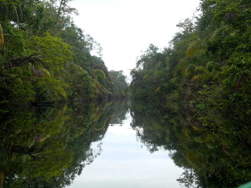 |
| Rainforest crowding the banks of the canals in Tortuguero NP, which provide the only access to the coast here. These canals were dug in the 1940s to connect natural waterways, and Tortuguero to the towns to the north and south along the coast. They were originally designed to move rainforest timber; this logging industry ended in the 1970s and now tourists flock here, especially to see the Green Turtles which lay eggs on the beaches at night. |
 |
| A small forest pool in rainforest at Esquinas Lodge in Piedras Blancas NP in the far south near the Pacific coast. |
 |
| Rainforest along the Puerto Viejo River, from the footbridge over it at La Selva Biological Research Station, just 60masl, though it is 60km inland from Tortuguero. This superb destination (which provides public accommodation) is run by the Organisation for Tropical Studies, a consortium of over 50 universities in Costa Rica, the US, Mexico, Peru and South Africa. Its 1600ha of largely primary rainforest adjoins the northern edge of the 47,000ha Braulio Carrillo NP, and contains some 60km of walking tracks. A must for anyone reading this blog when you visit Costa Rica! |
 |
| Baird's (or Central American) Tapir Tapirus bairdii, a widespread though not usually easy to see inhabitant of the rainforests, though it can also be found to above the tree line. |
 |
| Rainforest canopy at Tapirus Lodge, a private reserve to the south of La Selva, still on the Caribbean slope and on the eastern boundary of Braulio Carrillo NP. This was taken from the remarkable canopy-level cable car (or 'aerial tram') which offers an hour return trip, with the option of disembarking at the top. |
 |
| Morning mist over the rainforest along the access road to Tapirus Lodge. The lodge is at 500masl, so at about the elevation where lowland rainforest gives way to highland cloud forest on the Caribbean slopes, though this happens at somewhat higher elevations on the Pacific side. |
 |
| Cloud forest living up to its name at 1800masl on the Pacific slope of the Talamanca Mountains, above and below. |
 |
| Climbers are characteristic here, as they are at lower elevations. |
 |
| Also characteristic of cloud forests are epiphytes - both these and the climbers are using the structure of the trees to get up to the essential sunlight. This superb display of bromeliads is seen from the deck at the excellent Paraiso Quetzal ('Quetzal Paradise') Lodge. This wonderful lodge is perched on the mountainside at 2650masl at the head of the Savegre Valley, south of San José on the Pacific slope of the Cordillera Central. |
 |
| Canopy epiphytes from the cable car at Tapirus Lodge - this really is an excellent way to experience the canopy. |
Another way is from the three kilometres of walking tracks at Selvatura Park in Monteverde, featuring eight suspension bridges over deep gullies, so that we're looking down on the canopy.
 |
| Cloud forest from above; Selvatura Park suspension bridges, Monteverde. |
 |
| A remarkable perspective of a female Mantled Howler Monkey Alouatta palliata and baby from a Monteverde suspension bridge. |
 |
| The walking tracks between the bridges are also deep in rich cloud forest. |
 |
| Walking tracks through the oaks follow the Savegre river and its streams... |
 |
| ... while vantage points enable us to admire the distinctive oak canopy. |
 |
| Male Resplendent Quetzal, Savegre Valley. This was from the balcony of a restaurant! The iridescent feathers look blue in this dim under-canopy light, but bright green in the sun. |
Above where the cloud forests end, at about 3000masl, is the páramo, a relatively small treeless region beginning with a zone of dwarf bamboo and low shrubs and grading into heathland and grassland.
 |
| Bamboos Chusquea spp. at the edge of the páramo at 3200masl in the Talamanca Range. |
 |
| Heathland páramo at 3400masl. |
 |
| Green Spiny Lizard Sceloporus malachiticus at 3400masl (and it was bleak and cold at the time!), one of the few reptiles that can survive at this altitude and quite common in the highlands. |
 |
| Partially cleared dry forest west of Monteverde. |
 |
| The understorey - here in Rincón de la Vieja NP in far north-western Costa Rica - is more open than in rainforest, with often thorny small trees and shrubs. |
 |
| Overstorey trees however can be 30 metres high, like this fig... |
 |
| ... and many species of pea, such as have covered the forest floor with flowers here (and below). |

 |
| Turquoise-browed Motmot Eumomota superciliosam, Rincón de la Vieja NP; this is the national bird of Nicaragua. |
 |
| Steam and gases being emitted from a fumarole on the hillside above a bubbling pool. |
 |
| Bubbling mud in a hot pool of it, above and below. |

Irazú Volcano, very close to San José, is Costa Rica's highest active volcano, at 3400masl. It has erupted more than 20 times in the past 300 years, most recently in 1994. Due to its proximity to the national capital, and its easy access, it is a popular destination. Technically you can see both coastlines from the top, but I suspect that doesn't happen very often, and certainly didn't while we were there. Everything you will read about it mentions the chemically-green lake in the crater, but in fact at the moment it is dry.
 |
| This, the main crater, is 750m across and 270m deep, and currently the floor is covered with volcanic sand and ash. The rim and surrounds are covered with typical páramo vegetation. |
 |
| Arenal Volcano from the Observatory Lodge. |
 |
| Post-eruption regrowth forest on the lower slopes of Arenal Volcano. |
 |
| Arenal Volcano, 50km away, seen from the lakes at Caño Negro. |
 |
| Forest-lined lake shore from a boat at Caño Negro. |
 |
| Another wetland a little to the east, near the cryptically named town of Medio Queso (ie middle cheese!). |
 |
| Least Bittern Ixobrychus exilis from the boat in the Medio Queso channels; this is not an easy bird to see normally. It is the smallest American heron, and one of the world's smallest. |
 |
| Neotropical River Otter Lontra longicaudis focussed on a fishy snack by the Rio Suerte. |
 | ||
| American Crocodile Crocodylus acutus below the Tarcoles River bridge. |
 |
| Mangroves with 'stilt roots' by the Tarcoles River. |
 |
| Roseate Spoonbill Platalea ajaja - surely the world's most beautiful spoonbill - preening by the Tarcoles River. (And the apparenly odd species name is based on a Tupi name for the bird, from Brazil.) |
 |
| Brown Pelicans Pelecanus occidentalis at the mouth of the Tarcoles River, with the Pacific Ocean behind. |
Well that's a brief introduction to a fascinating - and to my mind entrancing - country. As I've already promised, there will be two more offerings to introduce some of its superb wildlife, but I'll probably come back to Australian topics before and between them. Meantime, if you have a world wish list and are as fascinated by the natural aspects of as much as I am, Costa Rica deserves a place on that list.
Should you wish to be added to it, just send me an email at calochilus51@internode.on.net. You can ask to be removed from the list at any time,or could simply mark an email as Spam, so you won't see future ones.
4 comments:
Wonderful blog as usual Ian, thank you. How wonderful to see a Splendid Quetzal. Looking forward to the next Costa Rica bogs.
Thanks you for such a fascinating introduction to a country of which I have been completely ignorant! I will have to re-read the blog with a map beside me to try to get a feel for the contours, the forests, lakes, volcanoes - a setting for such a variety of flora and fauna.
Kath H
Thanks Marita, and I'm sorry I missed this comment earlier. Next CR post coming up next week!
Always good to hear from you Kath, and so glad you enjoyed the post; it really is a special country. I too love having a map at my side at such times.
Hi Ian,
would love to subscribe to your blog but the email address comes back as not valid.
Thanks,
Janet Maddern
janet.maddern@det.nsw.edu.au
Post a Comment