
I'm not a sea person by nature - it's definitely not my element - but I love boat trips, and one I can highly recommend is the 20 hours on Navimag's ferry from Puerto Montt to Puerto Chacabuco in southern Chile. The travel time varies quite a bit, and departure and arrival times seem utterly arbitrary, though they leave sometime from late afternoon to late at night. But, this is South America. So where, more specifically, are we talking about?

It starts at 42 degrees south (about Hobart, for Australian readers) and heads south along the coast for some 400 kilometres. That doesn't give you any feeling for it though; mostly we are passing through channels and between islands and the coast, before turning east up Aisén Sound (Seno Aisén). This is a marvellously complex coast line.
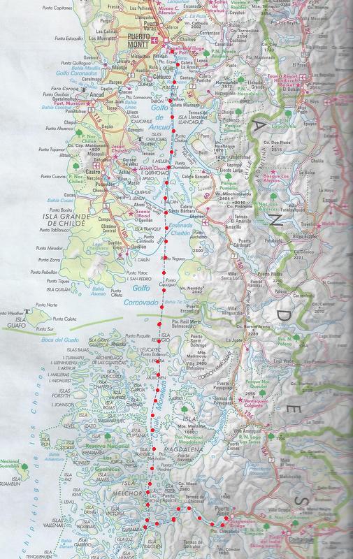
The dotted red line is the route. It starts from the industrial port of Puerto Montt, travels through the Gulf of Ancud, between the island of Grande Chiloé and the mainland. Chiloé represents the point at which the Cordillera de la Costa (the Coastal Range) - a lower range which parallels the mighty Andes, closer to the coast - runs into the sea. South of there the range continues as an archipelago of emergent mountains, the Chonos Archipelago, the northern part of which is the Guitecas Archipelago. Before we get to the sheltered waters of the deep Moraleda Channel however, between the Chonos and the mainland, we cross the Corcovado Gulf, the only unprotected part of the trip. Finally, in the maze of islands, we turn east up the narrow and spectacular Aisén Sound. Another important part of the spectacle is the Andes themselves, which are edging close to the sea by now; they too run into it further south.
 |
| Ferry in front of Volcano Corcovado. |
The ferries are run by Navimag (an abbreviation of Magellanic Navigation) which has a monopoly; there is little road access to the communities of this incredibly broken coast, and they rely almost entirely on Navimag to deliver. The ferries are freight carriers first, which also cater for local passengers, and finally tourists; having said that, the little cabins are quite adequate, food is good if basic, and the bar is well-stocked. And the scenery is amazing. (They also go all the way to Puerto Natales, far to the south.)
 |
| The ferry Puerto Eden, which does this run, at Puerto Chacabuco. |
Puerto Montt is not somewhere you'd really visit for its own sake, though the setting is superb, and it is the arrival point for both Chiloé and the beautiful lakes area inland.
 |
| Sunset (at about 9pm) on Volcano Chacabuco, behind Puerto Montt. |
We tend to pass most of Chiloé at night, waking to the beginning of the Corcovado Gulf. Depending on the conditions, sunrise on Volcano Corcovado can look like this....

or this...

The gulf itself is now known to be a Blue Whale breeding ground, though I've spent days peering without seeing one; I'll keep trying though!
Other marine animals, including sea lions and dolphins, are easier to see.
 |
| Sooty Shearwaters Puffinus griseus (above and below) are abundant. |

 |
| Black-browed Albatrosses Thalassarche melanophrys |
 |
| Southern Fulmar Fulmarus glacialoides |
And the scenery is always stunning.
 |
| Canal Moraleda, above and below. |

The only settlement we see during the entire trip is little Puerto Aguirre on Las Huichas; there are no roads there. We don't visit it, though there are regular ferry services.

The trip up the Aisén Sound is one of the highlights of the journey. The birds, ubiquitous until here, mostly leave us at this stage; they are children of the wind and don't appreciate the stillness. However the experience of sailing through the Andes is special.
 |
| The snows and glaciers continue into the great permanent ice fields. |

 |
| One of the joys of the trip up the Sound is not knowing what's around the next corner. |

Finally, it is almost an anticlimax to find yourself looking at Puerto Chacabuco, having been certain on several occasions that the fjord was about to end.

This somewhat bleak little port - and the larger Puerto Aisén just beyond it - are unlikely to be your destination per se, though the beautiful high country beyond is well worth the journey.
On the other hand, this journey is its own reward.
BACK FRIDAY
2 comments:
I notice the sea is very flat there according to your photographs. Is that guaranteed by the barrier islands or were you just lucky?
I recall the ferries from Dar es Salaam to Zanzibar which rocked alarmingly when exposed to the Indian Ocean but then settled down as soon as in the wind shadow of the many small islands
Martin
Martin, as you know, in nature OR South America nothing is guaranteed - let alone both together! However the barrier of islands is a very good protector. I've known it roll a bit across the Golfo Corcovado, but only ever very benign elsewhere, even when it's very windy, which is mostly. Having said that, I've seen a video (youtube?) which shows indoor furniture careering about quite alarmingly, but that could well have been further south.
Post a Comment