
Back to Australia for this one, and to one of the most spectacular and most-visited parks in inland New South Wales. The Warrumbungles boast dramatically jagged volcanic skylines, short strolls and Serious Challenges for Serious Walkers. The flowers in spring are magnificent (though I've not been there in spring since I've had a digital camera) and the birding is very good. The range provides a fascinating merging of plants and animals of the inland plains with those of the near-coastal ranges.
 |
| The view of the Warrumbungles skyline from the west (the 'back entrance' from the road through Tooraweenah). Most people probably come at it from the east, along the Newell Highway north through Dubbo and Gilgandra, or south through Narrabri, to Coonabarabran then west along the John Renshaw Parkway. Either way all roads are sealed. It's only 35k from Coonabarabran so day trips are very 'doable' indeed. |
 |
| For those less familar with Australian geography, the location of the Warrumbungles is indicated above (approximately!) by the end of the red arrow. |
 |
| For a more accurate indication, click on this map of NSW to enlarge it, and look for the purple star to the east of the NEW SOUTH WALES label in the centre of the map. |
The base rocks of the park are formed of sediments laid down under vast lakes some 150 million years ago in a steamy world dominated by dinosaurs. These layers can still be seen where the more recent overlaying volcanic rocks have eroded away.
 |
| Sandstones in Burbie Canyon, an easy walk not far from the road. |
 |
| And a sandstone gorge along Wambelong Creek on the Nature Walk near Canyon Camp, |
Much more recently - but still between 17 and 13 million years ago - volcanic activity, sometimes comprising slow flows of lava across the landscape, at other times featuring spectacularly violent explosions, redefined the Warrumbungle landscape. Laval flows and a rain of ash and lumps of glowing semi-molten rock covered the old sandstones and mudstones. Where the exuded lava was heavy and viscous it piled up around the vent to form domes which have since eroded to lose their smooth conical shape. In other places the vents become clogged with cooling lava and erosion revealed these 'plugs' standing alone. The famous Breadknife is a long narrow ridge of volcanic rock, a dyke, which cooled in a crack in the sandstone. The best easily accessible view of landscape can be had from the White Gum Lookout, a short walk from the carpark.
 |
| Refer to numbers in pic below to read this interpretation of key points of the view above. 1. Crater Bluff, a volcanic plug: 2. Belougery Spire - a volcanic spire can be formed either by viscous lava flowing slowly out of the vent, or setting within it. This was one of the central vents of the Warrumbungle volcano: 3. The Breadknife, a volcanic dyke - see above for an explanation of its formation: 4. Bluff Pyramid: 5. Bluff Mountain, a dome of viscous lava which piled up around the vent; the cliffs to the right of the mountain are 250 metres high. |

 |
| Mount Exmouth, at 1200 metres above sea level is the highest point in the park, 300 metres above the surrounding plain. It represents the remnant of a broad flow of less viscous lava which cooled in a thick blanket and is gradually eroding away. |
Our camp at Wambelong Campground was below another magnificent volcanic plug, Belougery Split Rock. Here it is glowing superbly in the sunset.
 |
| We didn't see much sun in our recent stay but this rock lit up at sunset on two consecutive nights, which cheered us immensely. |
Here are a couple more volcanic features, either outside or just inside the eastern boundary.
 |
| A plug by the road outside the park boundary. |
 |
| A spire on a wet cloudy day in 2015. This was just two years after devastating bushfires which burnt 90% of the park, hence the tree skeletons in the foreground. |
 |
| River Oaks Casuarina cunninghamiana recovering from the fire nine years after the event. |
Our most recent visit was in early June 2022 when La Niña still held sway. In fact very heavy rain and winds delayed our arrival and we lost a couple of precious camping nights. The rain finally finished but the temperature never climbed into double figures; however you've got to make the most of what you get!
 |
| Flood debris in Burbie Canyon above, and along Wambelong Creek below; a lot of this was from fire-killed trees. |
 |
| This walk was closed by the high water just a little further along. |
 |
| Our very pleasant little nook and set-up. |
 |
| The White Cypress Pine Callitris collemularis in the left foreground is typical of the woodlands of the slopes, as is the old Kurrajong Brachychiton populneus below. |

 |
| Narrow-leaved Ironbark Eucalyptus crebra is another typically inland species in this part of the world, though it does go to the coast further south. |

A particularly interesting association can be seen in the creekline near the visitors' centre (which incidentally is well worth a visit for the park information available). Across most of inland Australia streamlines are dominated by River Red Gums Eucalyptus camaldulenis. As we approach the coast in this part of the world however they are replaced by the River Oaks that we met above. At this site they do the 'changeover' and both grow together - I'm sure it must happen elsewhere but I haven't seen it.
 |
| The light really was awful but at least you can see the two species growing atypically together, with the River Red Gum on the right. |
 |
| The double-headed specimens I find especially satisfying. You can find a whole post on them here. |
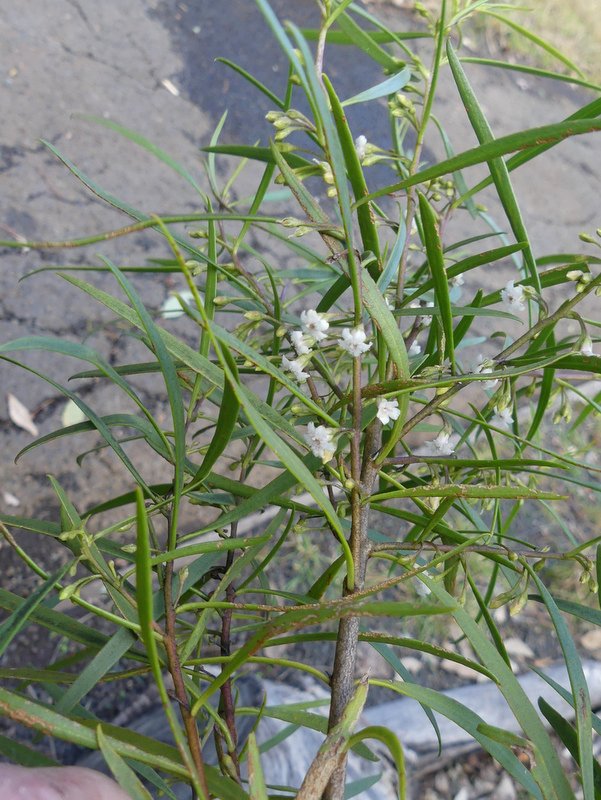 |
| Watrer Bush Myoporum montanum. |
 |
| Parrot Pea Dillwynia retorta. |
 |
| Bitter Cryptandraa Cryptandra amara. |

 |
| Bracket fungi (here growing on an ironbark still showing the effects of the 2013 fire, and in the next two photos) put out their spore bodies from inside the trunk. Unlike most other fungi spore bodies (such as toadstools or mushrooms) these are woody and long-lasting. |


 |
| These were growing among the low herbs of the campground... |
 |
| ... these from a fallen log... |
 |
| ... and these from the ground litter. |
The vegetation of the park is not typical of the region as a whole. As with most other parks of the slopes the range was eventually preserved because of its unsuitability for agriculture, while the surrounding rich woodland plains were largely cleared and deprived of most of their natural values. (To the north of the Warrumbungles the vast ironbark/cypress pine woodlands of the Pilliga are an exception to this rule.) The range was little known, despite calls in 1936 by the National Parks and Primitive Areas Council for a 'Warrumbungles National Monument'. A very modest little park of 3400 hectares was finally declared in 1952 for the purpose of public recreation but it only became widely known after famed photographer and film-maker Frank Hurley walked and camped there, and took photos which became familar to many. But I can't find any date for this that is more accurate than 'the first half of the 20th century'! After the purchase of surrounding properties as they came on the market, the size of the park is now 23,300 hectares - still modest but a definite improvement!
Animals were for the most part staying low during our recent stay, understandably given the pretty miserable conditions! As in any cleared area in eastern Australia, Eastern Grey Kangaroos were plentiful in campgrounds and picnic areas.
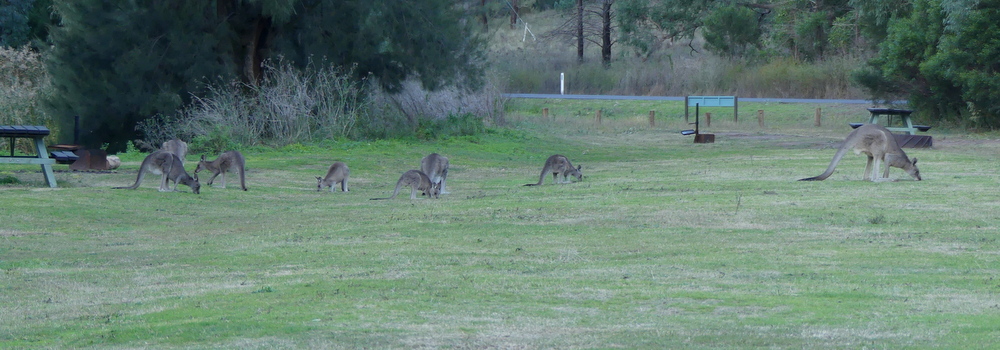 |
| Some of the mob which shared Camp Wambelong with us, taken early one morning. |
 |
| Red-necked Wallaby Macropus (now widely called Notamacropus) rufogriseus; found throughout most of eastern Australia. |
 |
| A battle-scarred Wallaroo Macropus robustus, a dark stocky hill kangaroo of the eastern ranges. Across the rest of dry Australia is a reddish form usually called a Euro. |
Naturally there were no reptiles active in those temperatures, and only a few invertebrates appeared.
 |
| It seems that there'll nearly always be a mosquito somewhere; this one was lurking with intent on the toilet wall. |
 |
| I think this one - on the point of succumbing to the cold - was a ghost moth, Family Hepialidae, but I'm happy to take other suggestions. |
There were certainly birds around but many of them were staying safely in cover; however a few were quite willing to be captured for posterity (images only, you understand!). As with most of our camps in recent times, Apostlebirds featured strongly.
 |
| Bold garrulous larrikins which (quite rightly) treat a campground as their own, Apostlebirds Struthidea cinerea are old Australians, mud-nesters which are among the most strongly developed cooperative breeders in the world. |
 |
| Grey-crowned Babbler Pomatostomus temporalis foraging in the campground. More on them here. |
 |
| A pair of Jacky Winters Microeca fascinans, plain-coloured but highly engaging Australian robins, had set up territory here and found the boundary fence a highly satisfactory vantage point. |
 |
| Male Turquoise Parrot, the highlight of our time in the Warrumbungles. They were feeding some of the time with the little Red-rumped Parrots, which looked positively hulking by comparison! |
 |
| This photo just shows the lovely red wing patch which is almost hidden by the wing coverts. |
 |
| Rainbow over Camp Wambelong. |
Should you wish to be added to it, just send me an email at calochilus51@internode.on.net. You can ask to be removed from the list at any time,or could simply mark an email as Spam, so you won't see future ones.
2 comments:
I first went to the Warrumbungles in late 1964 with my brother. We stayed in an old Sydney tram which had been converted to accommodation. It was extremely hot and when we got back from a walk biwe went in to escape the hordes of bush flies - and it was so hot we thought the flies weren't that bad... It was very different from bushwalks in SE Qld and we really enjoyed exploring. In the 1970s I returned with my husband and children on more than one occasion, on our annual trips from Canberra to see family in Brisbane. I am glad to see the recovery after the devastating fires. I think it is best to avoid visiting in school holidays and at holidays like Easter and Christmas if you don't like crowds.
Hi Kath. I'm always glad to hear that I've sparked good memories for people, and you're particularly good at letting me know - you've also good an excellent trove of memories! The trams were removed not that long ago - well actually it was 1986 I now see. And you're absolutely right re school holidays etc - we feel crowded though if we can even see another camp! Thanks for writing.
Post a Comment